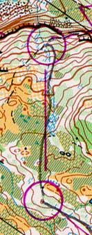
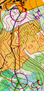
| 1. 190m
2:03; (10:47/k) leg 81st/115 |
2. 375m
3:40; (9:46/k) leg 85th, total 82nd |
||||
 I was the third to last
starter on this course, so by the time I went, everyone was pretty much finished.
The start stages were pretty long so by the time I had gotten near the start triangle, the
runner before me was gone, and I had no idea which way the first control was. I
hesitated quite a bit on this control, but after I settled in and decided where I was, and
where the control was, I found it easily. I was the third to last
starter on this course, so by the time I went, everyone was pretty much finished.
The start stages were pretty long so by the time I had gotten near the start triangle, the
runner before me was gone, and I had no idea which way the first control was. I
hesitated quite a bit on this control, but after I settled in and decided where I was, and
where the control was, I found it easily. |
 This open area was really
cool, you could pretty much see forever. I started heading up to the top of this
hill, and once I was down the other side I contoured around the large one. I knew
about where I was coming into this since I could see the pond to the north. I saw the
control to the right, and a little behind me. This open area was really
cool, you could pretty much see forever. I started heading up to the top of this
hill, and once I was down the other side I contoured around the large one. I knew
about where I was coming into this since I could see the pond to the north. I saw the
control to the right, and a little behind me. |
||||
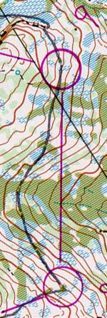
| 3. 325m
2:41; (8:15/k) leg 81st, total 81st |
4. 325m
3:18; (10:09/k) leg 77th, total 79th |
||||
 Again, I could see pretty
much were I wanted to go for this control so I just headed that way on rough compass.
At this point some dude who started 2 minutes behind me came flying by and was
later disqualified for some reason. anyway once I got to the edge of the open I ran to
where I thought the cliff should be and found the control there. Again, I could see pretty
much were I wanted to go for this control so I just headed that way on rough compass.
At this point some dude who started 2 minutes behind me came flying by and was
later disqualified for some reason. anyway once I got to the edge of the open I ran to
where I thought the cliff should be and found the control there. |
 I started off for this
control and contoured a little to save elevation. then ran across the marsh and up towards
the big cliffs. when I got to the reentrant I looked around some and found the
control a little lower than I expected. I started off for this
control and contoured a little to save elevation. then ran across the marsh and up towards
the big cliffs. when I got to the reentrant I looked around some and found the
control a little lower than I expected. |
||||
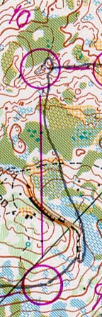
| 5. 1075m
9:47; (9:06/k) leg 86th, total 83rd |
6. 675m
4:28; (6:37/k) leg 78th, total 81st |
||||
 This long leg was totally
open. my strategy from control 1 was to walk up any steep hills, and save my energy
for later since I was way out of shape for this. This payed off in reducing (but not
eliminating) my delirium towards the end. When I was at the top of the first hill, I
ran down and along the left side of the valley crossing over at the pond. I
contoured some and then decided to go straight up. I continued on rough compass and used
the large pond to collect myself. I climbed the next hill and then saw where I
thought the control should be. I ran there and looked at the map closer to see that
the control was in a marsh and not on the cliff below. I went up the rock face and
right into the control. This long leg was totally
open. my strategy from control 1 was to walk up any steep hills, and save my energy
for later since I was way out of shape for this. This payed off in reducing (but not
eliminating) my delirium towards the end. When I was at the top of the first hill, I
ran down and along the left side of the valley crossing over at the pond. I
contoured some and then decided to go straight up. I continued on rough compass and used
the large pond to collect myself. I climbed the next hill and then saw where I
thought the control should be. I ran there and looked at the map closer to see that
the control was in a marsh and not on the cliff below. I went up the rock face and
right into the control. |
 I ran up and over a knoll,
then down the north side, using the contours and the fact that I could see really far to
follow the marshes and streams downhill. when I got out of the open I ran straight along
the shallow hillside trying to stay in the middle. I came into the knoll and saw the
control to the right. I ran up and over a knoll,
then down the north side, using the contours and the fact that I could see really far to
follow the marshes and streams downhill. when I got out of the open I ran straight along
the shallow hillside trying to stay in the middle. I came into the knoll and saw the
control to the right. |
||||
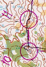
| 7. 380m
2:30; (6:35/k) leg 87th, total 80th |
8. 375m
2:56; (7:49/k) leg 86th, total 82nd |
||||
 I ran up the slope and into
the open marsh, then followed the right edge of it and the watercourse down into the
control. towards the bottom the stream started wandering and it was a little
difficult to see which was the main one and which were just gullies. when I got to
the trail I was a little bit to the right of it I ran up the slope and into
the open marsh, then followed the right edge of it and the watercourse down into the
control. towards the bottom the stream started wandering and it was a little
difficult to see which was the main one and which were just gullies. when I got to
the trail I was a little bit to the right of it. |
 Coming out of this control I
had to follow a taped route down some really steep and wet cliffs. there was a big
rope there to hold on to and I went down pretty carefully. when I got to the end of
the route at the triangle I continued straight in between the large knoll and the smaller
one to the right. using a rough bearing I followed a marsh right into the control,
and saw it from like 40m away. Coming out of this control I
had to follow a taped route down some really steep and wet cliffs. there was a big
rope there to hold on to and I went down pretty carefully. when I got to the end of
the route at the triangle I continued straight in between the large knoll and the smaller
one to the right. using a rough bearing I followed a marsh right into the control,
and saw it from like 40m away. |
||||
| 9. 525m
4:17; (8:09/k) leg 64th, total 82nd |
10. 525m
5:58; (11:22/k) leg 85th, total 83rd |
||||
 I started out contouring way
to the left, and out into the open area. going back into the other side, I started to
climb a little, and ran on a rough compass bearing. I came into an open space and
realized right where I was. I continued straight across and came straight into the
control, although I was only a few meters away when I saw it. I started out contouring way
to the left, and out into the open area. going back into the other side, I started to
climb a little, and ran on a rough compass bearing. I came into an open space and
realized right where I was. I continued straight across and came straight into the
control, although I was only a few meters away when I saw it. |
 running around the hill, I
had to back up a little when I got to some steep cliffs that I couldn't go down. the
marsh was pretty open, but I was going slow up the hill. I came down the other side of the
hill, guided by the vegetation features, but when I got to the bottom the control was not
where I expected. I circled around quickly and then stopped to look carefully at the
map. I found the control further to the left, where I had not seen it before, since it was
in the bottom of a depression. running around the hill, I
had to back up a little when I got to some steep cliffs that I couldn't go down. the
marsh was pretty open, but I was going slow up the hill. I came down the other side of the
hill, guided by the vegetation features, but when I got to the bottom the control was not
where I expected. I circled around quickly and then stopped to look carefully at the
map. I found the control further to the left, where I had not seen it before, since it was
in the bottom of a depression. |
||||
| 11. 175m
1:26; (8:11/k) leg 85th, total 83rd |
12. 350m
5:26 (15:31/k) leg 92nd, total 86th |
||||
 I ran off on a good compass
bearing, being careful since I just messed up the one before. I came across the open area
and saw the first reentrant. I went over the small spur to where the rock face was,
and saw the control to the right up the reentrant. I ran off on a good compass
bearing, being careful since I just messed up the one before. I came across the open area
and saw the first reentrant. I went over the small spur to where the rock face was,
and saw the control to the right up the reentrant. |
 I came out and contoured
across the hillside. I got pretty confused coming down the last spur before the control. I
got pulled down the reentrant too far, and was confused by a cliff that was not on the
map, although there was camoflage netting over it so we wouldn't see it. of course
that didn't do much to say where I was. I decided to go across some, and found the
control on another cliff a hundred meters further. I came out and contoured
across the hillside. I got pretty confused coming down the last spur before the control. I
got pulled down the reentrant too far, and was confused by a cliff that was not on the
map, although there was camoflage netting over it so we wouldn't see it. of course
that didn't do much to say where I was. I decided to go across some, and found the
control on another cliff a hundred meters further. |
||||
| 13. 375m
4:22; (11:38/k) leg 82nd, total 84th |
14. 650m
4:16; (6:34/k) leg 60th, total 83rd |
||||
 I ran out on compass and
contouring straight across the hill. when I was almost to the marsh I had to drop
down some because of the large rock faces. I then followed the marsh until there was
a good place to go up the left side, and I climbed over the little spur, and then
contoured across. I stopped a little bit short to look around, but then found the
control further on and up a litttle. I ran out on compass and
contouring straight across the hill. when I was almost to the marsh I had to drop
down some because of the large rock faces. I then followed the marsh until there was
a good place to go up the left side, and I climbed over the little spur, and then
contoured across. I stopped a little bit short to look around, but then found the
control further on and up a litttle. |
 After coming out straight
down the hill, I turned left and followed the right edge of the marsh and then a small
stream downhill running (relatively) hard. when I got to the end of the open, I left
the stream, and went straight for the two knolls, attacking from there. I ran across
the two small reentrants and stopped 3m above the control to look around, then saw it. After coming out straight
down the hill, I turned left and followed the right edge of the marsh and then a small
stream downhill running (relatively) hard. when I got to the end of the open, I left
the stream, and went straight for the two knolls, attacking from there. I ran across
the two small reentrants and stopped 3m above the control to look around, then saw it. |
||||
| 15. 275m
2:33; (9:16/k) leg 90th, total 83rd |
16. 1900m
16:56; (8:55/k) leg 79th, total 84th |
||||
 I ran down the hill to the
dirt road, and then up the point of the marsh and across the three knolls. I tried
to use the last small knoll as an attack point, but it was not well defined, so I ended up
20m too high in the reentrant. I saw the control when I got to the reentrant and
turned downhill to it. I ran down the hill to the
dirt road, and then up the point of the marsh and across the three knolls. I tried
to use the last small knoll as an attack point, but it was not well defined, so I ended up
20m too high in the reentrant. I saw the control when I got to the reentrant and
turned downhill to it. |
 I started off running in the
direction of the purple line since the control was so far away I couldn't see it folded
under somewhere on the map. I decided to contour across the hill and pick up the
trail, although following the marshes up and to the right would have been good too.
I had to go down further than I wanted because the gully was lined with cliffs that I
couldn't get down. I went until I could get across and then contoured to the
trail. I followed it up to a ruin and then contoured across again to the next trail.
After running up that one a little I cut off left again and started downhill
following a stream. I then went across the top of the open (which was really crappy)
meaning to stay up all the way to the control. then I saw the rocky ravine on the
map and knowing it would be worse than the one at the beginning of the leg, I went
down to the trail. I ran along that to a reentrant, then followed that and a french
guy (more about him later) to the control. I started off running in the
direction of the purple line since the control was so far away I couldn't see it folded
under somewhere on the map. I decided to contour across the hill and pick up the
trail, although following the marshes up and to the right would have been good too.
I had to go down further than I wanted because the gully was lined with cliffs that I
couldn't get down. I went until I could get across and then contoured to the
trail. I followed it up to a ruin and then contoured across again to the next trail.
After running up that one a little I cut off left again and started downhill
following a stream. I then went across the top of the open (which was really crappy)
meaning to stay up all the way to the control. then I saw the rocky ravine on the
map and knowing it would be worse than the one at the beginning of the leg, I went
down to the trail. I ran along that to a reentrant, then followed that and a french
guy (more about him later) to the control. |
||||
| 17. 250m
4:10 (16:40/k) leg 93rd, total 85th |
18. 280m
2:38 (9:24/k) leg 85th, total 85th |
||||
 This one was pretty short but
I still messed it up, since I didn't do a good job of counting contours. the lost
french guy didn't help either. I looked around and eventually went out to the ski
slope and relocated. I had not gone up enough before. Sometime around here I
unfolded the map expecting to see one or two controls and the finish, only to discover
that I had more than 5k left in the course. that was a bad feeling. This one was pretty short but
I still messed it up, since I didn't do a good job of counting contours. the lost
french guy didn't help either. I looked around and eventually went out to the ski
slope and relocated. I had not gone up enough before. Sometime around here I
unfolded the map expecting to see one or two controls and the finish, only to discover
that I had more than 5k left in the course. that was a bad feeling. |
 I ran back out to the open
and across to the other side, thinking I would try to hang with this french dude. (funny)
when I came out on the rough open area, I saw the trail down hill and knew that I
was above the control. The other guy looked confused and then I decided not to follow him.
I ran across and then down the hill into the control. he was close behind. I ran back out to the open
and across to the other side, thinking I would try to hang with this french dude. (funny)
when I came out on the rough open area, I saw the trail down hill and knew that I
was above the control. The other guy looked confused and then I decided not to follow him.
I ran across and then down the hill into the control. he was close behind. |
||||
| 19. 1090m
10:33 (9:41/k) leg 76th, total 85th |
20. 750m
8:11 (10:54/k) leg 86th, total 86th |
||||
 I looked for a route on this
one, and seeing none, decided to just run towards the control and worry about the rest
later. (I do that more often then I should) There were a lot of perpendicular
features that I used to figure out far I had gone. I wasn't exactly sure where I was
on the hill though, until I hit the second trail right where a little spur came off.
french guy in tow, I ran (slowly at this point) a little more upwards on the hill
through the semi open and collected on the point of the reentrant into the open marsh. I
came out the other end of the marsh and onto a trail for a few meters, then along a flat
area, turning uphill when I could see where everyone else had slid down the wet hillside
coming out of the control. I looked for a route on this
one, and seeing none, decided to just run towards the control and worry about the rest
later. (I do that more often then I should) There were a lot of perpendicular
features that I used to figure out far I had gone. I wasn't exactly sure where I was
on the hill though, until I hit the second trail right where a little spur came off.
french guy in tow, I ran (slowly at this point) a little more upwards on the hill
through the semi open and collected on the point of the reentrant into the open marsh. I
came out the other end of the marsh and onto a trail for a few meters, then along a flat
area, turning uphill when I could see where everyone else had slid down the wet hillside
coming out of the control. |
 The french guy (ok his name
was jean-something) came out of this one pretty fast, and passed me going down the hill.
of course he soon stopped to "look at the map" until I went by again.
we ran down to the stream and then up the steep slope on the other side into the
flat marsh area. I sort of contoured along the hill heading across and down,
planning to collect on one of the big marshes down there (they are really good for that)
I knew pretty much where I was when I got there due to the second open area that I
could see, and headed up the hill. we went too far on the hillside and went past the
control. Jean-french saw this one and got to it first, then took off back down the
hill. The french guy (ok his name
was jean-something) came out of this one pretty fast, and passed me going down the hill.
of course he soon stopped to "look at the map" until I went by again.
we ran down to the stream and then up the steep slope on the other side into the
flat marsh area. I sort of contoured along the hill heading across and down,
planning to collect on one of the big marshes down there (they are really good for that)
I knew pretty much where I was when I got there due to the second open area that I
could see, and headed up the hill. we went too far on the hillside and went past the
control. Jean-french saw this one and got to it first, then took off back down the
hill. |
||||
| 21. 1440m
14:28 (10:03/k) leg 87th, total, 85th |
22. 380m
5:32 (14:33/k) leg 83rd, total 85th |
||||
 This leg is a textbook
over-around route choice, and knowing I was pretty much dead I decided to go around to the
left. It was evident that the french guy decided (at first) to go over the hill.
good, I thought, maybe I can finally ditch him. so I ran along the edge of the
marshes, eventually picking up a small trail. after a hundred meters on it, who do I hear
coming behind me? yeah you guess it, jean-lost. At this point I had him figured out,
although I didn't care since I knew he must have started before me. (six minutes as it
turns out) anyway I got to the bottom, crossed the marsh, and came to the river. in
my semi-delirium (only 50% at this point) I decided that it would be funny to mess with
this dude a little bit. I then opted for the less-than-optimal route right down the
middle of the 20ft wide and 1ft deep river for a few hundred meters. sure enough I hear
wet feet behind me. having proved my point, I later left the fish behind in favor of
the dry(ish) land on the left side. I had to cross back over later, but then I knew
exactly where I was. I came out into the open marsh running across with light feet
since this one was a little wetter than all the rest. after putting one foot in a
particularly moist moss-free area I was soon up to my waist in smelly quick-mud. I
stood up trying to get out, and was shortly up to my armpits. Thinking this was very
bad, I hear frenchy yelling something behind me, probably thinking it was really good that
I went first. Unfortunately I couldn't think of any french curse words, so I
resorted to sort of swimming and rolling out of this sticky mud-pit until I could reach
something on one side. By this time Jean-less-muddy had gotten a hundred meters
worth of head start on me. against my better judgement (daze o meter at 75% by now)
I continued across the marsh, careful to avoid anyplaces without vegetation. on the
other side, I followed a reentrant up to the road then ran along it until turning left
into some kind of industrial gravel area. I climbed a hill on the other side and then ran
down into a depression where the control was. at this point I see my new friend leaving
the control. This leg is a textbook
over-around route choice, and knowing I was pretty much dead I decided to go around to the
left. It was evident that the french guy decided (at first) to go over the hill.
good, I thought, maybe I can finally ditch him. so I ran along the edge of the
marshes, eventually picking up a small trail. after a hundred meters on it, who do I hear
coming behind me? yeah you guess it, jean-lost. At this point I had him figured out,
although I didn't care since I knew he must have started before me. (six minutes as it
turns out) anyway I got to the bottom, crossed the marsh, and came to the river. in
my semi-delirium (only 50% at this point) I decided that it would be funny to mess with
this dude a little bit. I then opted for the less-than-optimal route right down the
middle of the 20ft wide and 1ft deep river for a few hundred meters. sure enough I hear
wet feet behind me. having proved my point, I later left the fish behind in favor of
the dry(ish) land on the left side. I had to cross back over later, but then I knew
exactly where I was. I came out into the open marsh running across with light feet
since this one was a little wetter than all the rest. after putting one foot in a
particularly moist moss-free area I was soon up to my waist in smelly quick-mud. I
stood up trying to get out, and was shortly up to my armpits. Thinking this was very
bad, I hear frenchy yelling something behind me, probably thinking it was really good that
I went first. Unfortunately I couldn't think of any french curse words, so I
resorted to sort of swimming and rolling out of this sticky mud-pit until I could reach
something on one side. By this time Jean-less-muddy had gotten a hundred meters
worth of head start on me. against my better judgement (daze o meter at 75% by now)
I continued across the marsh, careful to avoid anyplaces without vegetation. on the
other side, I followed a reentrant up to the road then ran along it until turning left
into some kind of industrial gravel area. I climbed a hill on the other side and then ran
down into a depression where the control was. at this point I see my new friend leaving
the control. |
 Jean-whatever left this
control and went around all the banks on the right side, but I (accurately) decided my
legs only had a few feet worth of climbing left, so I went back across the open area.
about when that green spur was to my right, I stepped into another mud-pit, and
immedeately begain thinking of swear words. luckily this one was only knee deep, and my
shoes where on tight enough that they did not get sucked off when I dragged my feet out of
it. my next [stupid] move was to fall into the dry and dusty bank on the other side, thus
coating my wet arms and legs with dirt, which of course stuck there. I stumbled
another hundred meters, trying to brush the crap off myself unsuccessfully, and the
haze-o-meter was approaching full. I somehow decided that now was the time to
eat/slurp a packet of powergel, one of the many aquired for free by working the boston
marathon, and the one of which I had carried with me the whole way so far. After a
dirty yet sweet tasting mouthful of a flavor I can't remember (I think it was strawberry
bannana since that has caffeine in it) I was still just as wasted, for lack of a better
word. It could have been worse, though. Apparently Peter Nelson, who did not
employ my walking up hill strategy from the beginning, layed near this control for half an
hour because he couldn't walk. So anyway I jogged/walked across the top of the
spur to the control, and could see frenchy crossing the road below, on the way to the next
control. Jean-whatever left this
control and went around all the banks on the right side, but I (accurately) decided my
legs only had a few feet worth of climbing left, so I went back across the open area.
about when that green spur was to my right, I stepped into another mud-pit, and
immedeately begain thinking of swear words. luckily this one was only knee deep, and my
shoes where on tight enough that they did not get sucked off when I dragged my feet out of
it. my next [stupid] move was to fall into the dry and dusty bank on the other side, thus
coating my wet arms and legs with dirt, which of course stuck there. I stumbled
another hundred meters, trying to brush the crap off myself unsuccessfully, and the
haze-o-meter was approaching full. I somehow decided that now was the time to
eat/slurp a packet of powergel, one of the many aquired for free by working the boston
marathon, and the one of which I had carried with me the whole way so far. After a
dirty yet sweet tasting mouthful of a flavor I can't remember (I think it was strawberry
bannana since that has caffeine in it) I was still just as wasted, for lack of a better
word. It could have been worse, though. Apparently Peter Nelson, who did not
employ my walking up hill strategy from the beginning, layed near this control for half an
hour because he couldn't walk. So anyway I jogged/walked across the top of the
spur to the control, and could see frenchy crossing the road below, on the way to the next
control. |
||||
| 23. 225m
2:56 (13:02/k) leg 39th, total 85th |
24. 400m
3:45 (9:22/k) leg 68th, total 85th |
||||
 I ran/fell down this bank and
quickly caught up to jean-baguette-legs. I went straight through the wet forest
part, crossing a few wet ditches but not counting them (no brain cells to spare)
frenchy was still ahead, but we were both going slowly since the control was in the middle
of nowhere. he climbed up over a bank, and made some french noise, indicating he'd
found the control. and for that I thank him. I went up after him and into the
control 3 meters later. I ran/fell down this bank and
quickly caught up to jean-baguette-legs. I went straight through the wet forest
part, crossing a few wet ditches but not counting them (no brain cells to spare)
frenchy was still ahead, but we were both going slowly since the control was in the middle
of nowhere. he climbed up over a bank, and made some french noise, indicating he'd
found the control. and for that I thank him. I went up after him and into the
control 3 meters later. |
 I went uphill some more and
into the open area. jean-dislocated was confused by another control there, but was soon
heading back off across the rough stuff. I was right on his heals, giving him a
taste of his own medicine. once we were into the forest, it was pretty fast running.
jean-lost went to far right, but I saw the control and beat him to it by a little. I went uphill some more and
into the open area. jean-dislocated was confused by another control there, but was soon
heading back off across the rough stuff. I was right on his heals, giving him a
taste of his own medicine. once we were into the forest, it was pretty fast running.
jean-lost went to far right, but I saw the control and beat him to it by a little. |
||||
| F. 200m
0:43 (3:35/k) leg 41st, total 85th |
Total.
13500m 129:33 (9:34/k) 85th/115 |
||||
 I took off as fast as I could
go down the strangely twisted finish chute. If it was the last thing I did, I was going to
beat this dude to the finish. I got there a few seconds ahead of Jean-Baptise
Bourrin, and consequently beat him by six minutes and four seconds. I took off as fast as I could
go down the strangely twisted finish chute. If it was the last thing I did, I was going to
beat this dude to the finish. I got there a few seconds ahead of Jean-Baptise
Bourrin, and consequently beat him by six minutes and four seconds. |
|
||||